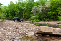
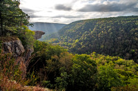
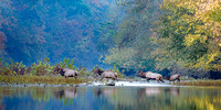
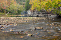
This gallery contains images of our nation's first national river, the Buffalo National River! It provides mile-by-mile views of the river for the areas I have visited since 2011. As of 2023, I'm up to 65 total miles photographed!
So far all of my exploration has been on foot, but at some point I'm going to have to learn to kayak and explore the remaining areas that way. It should be exciting!
During October/November of 2023, the river was very low which allowed me to explore a lot more of it than I could in the past. I took advantage of the opportunity and visited 35+ locations to capture as much of the Fall color as I could.
Thanks to the efforts of many others years ago, the Buffalo River is 153 miles of natural free-flowing beauty! The first 7 miles are not within a protected area, but all of the remaining 146 miles are. Miles 7.5 thru 17 are within the Upper Buffalo Wilderness area. Miles 17.1 thru 153 are within the Buffalo National River park which includes portions of the Ponca Wilderness and Lower Buffalo Wilderness areas.
I've titled each image with my best mile marker estimation from the NatGeo Trails Illustrated maps (east and west). The access point is included in the description so you can visit the locations yourself!
Resources:
#1 National Geographic Trails Illustrated maps for the Buffalo National River (east and west). These maps include mile markers for the river which helps me estimate the number of miles I have photographed.
#2 Buffalo River Handbook by Kenneth L. Smith. This handbook contains many many details about the river and has been invaluable for learning about the river.
I hope you enjoy the journey!
© Douglas F Hundley Photography